f
Size: a a a
2020 September 15
ну а что, велик есть
AL
велик есть, а маршрут приложится
f
*проложится
PG
Они будут пиарить.
Разработчики маршрута не они, это пиар-акция по разведке проложенного маршрута хипстерами.
Разработчики маршрута не они, это пиар-акция по разведке проложенного маршрута хипстерами.
ПЖ
Могут. Не вписанные в вики тэги называются непризнанными и не прошедшими утверждение.
и ??
и даже это не является причиной их удаления или неиспользования :)
any tag you like
и даже это не является причиной их удаления или неиспользования :)
any tag you like
PG
Это да. Хоть чорта лысого замапь, наказания за перегрузку подосновы нету. А жаль.
f
Это да. Хоть чорта лысого замапь, наказания за перегрузку подосновы нету. А жаль.
есть - отсутствие Ладоги
ПЖ
Это да. Хоть чорта лысого замапь, наказания за перегрузку подосновы нету. А жаль.
мда, если бы была бы...
ой сколько крови в чатах полилось бы, ой сколько бы вскипело и разбрызгало...
ой сколько крови в чатах полилось бы, ой сколько бы вскипело и разбрызгало...
l
подоснову перегрузили не спинки лавочек, а Ладога
KK
не важно где она есть, важно откуда он взял эту
Вот же, пишут что:
For example, data created by tracing over Google Maps, or by using the Google Maps API, is not acceptable for use in OSM.
You would need to recreate it using OSM as a basemap.
Similarly, data built on a commercial dataset such as those offered by TomTom or HERE will not be acceptable.
ЛЭП не адреска. Кто запрещает, глядя в кадастровую карту, нарисовать линию в OSM?
PG
мда, если бы была бы...
ой сколько крови в чатах полилось бы, ой сколько бы вскипело и разбрызгало...
ой сколько крови в чатах полилось бы, ой сколько бы вскипело и разбрызгало...
Да ладно тебе. За полгода всех троцкистских шпионов расстреляли бы - такая бы житуха началась...
A
f
Вот же, пишут что:
For example, data created by tracing over Google Maps, or by using the Google Maps API, is not acceptable for use in OSM.
You would need to recreate it using OSM as a basemap.
Similarly, data built on a commercial dataset such as those offered by TomTom or HERE will not be acceptable.
ЛЭП не адреска. Кто запрещает, глядя в кадастровую карту, нарисовать линию в OSM?
For example, data created by tracing over Google Maps, or by using the Google Maps API, is not acceptable for use in OSM.
You would need to recreate it using OSM as a basemap.
Similarly, data built on a commercial dataset such as those offered by TomTom or HERE will not be acceptable.
ЛЭП не адреска. Кто запрещает, глядя в кадастровую карту, нарисовать линию в OSM?
не важно что, ты использовал источник, который не давал согласия, и очень сильно борется, чтобы его данные не продавали налево
IZ
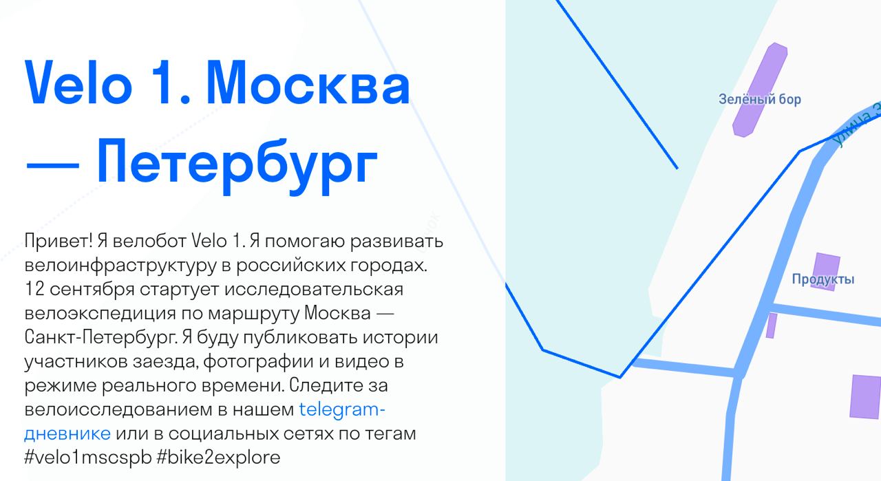
Тут про свой поход пишут: @velo_one
«У паромной станции, кстати, тоже есть магазин, но на карте он не отмечен»
https://www.openstreetmap.org/#map=18/56.69613/36.73329
5 лет назад
хмммммммм
https://www.openstreetmap.org/#map=18/56.69613/36.73329
5 лет назад
хмммммммм
PG
«У паромной станции, кстати, тоже есть магазин, но на карте он не отмечен»
https://www.openstreetmap.org/#map=18/56.69613/36.73329
5 лет назад
хмммммммм
https://www.openstreetmap.org/#map=18/56.69613/36.73329
5 лет назад
хмммммммм
Я подозреваю, что как любые хипстеры, они по Яндексу едут. Так-то я всю их информацию сразу проверяю.
IZ
В целом там очень смешно, я за ними слежу, кучка хипстеров на смешных круизерах решила по грунтам доехать своим ходом до Питера. Я надеюсь, когда у них будет первая серьёзная поломка, они справятся, а не бросят своего пострадавшего товарища одного в лесу. :)
это чудовищно. Почему они не нашли какого-нибудь нормального велосипедиста в компанию
IZ

более того, этот магазин на их собственном сайте на карте нарисован
IZ
как бы с этими хипстерами связаться
IZ
пока они в новгородских болотах по яндекс-картам без интернета не сгинули
f
осмер "продукты" бы не написал


